| Application at a Glance 申请类型 Agricultural meteorology Project area Pacific Northwest Contributors Peter L. Palmer Regulating agency US Bureau of Reclamation Datalogger CR10X Communications GOES satellite Measured parameters Wind speed and direction, 空气温度,湿度,降水 |
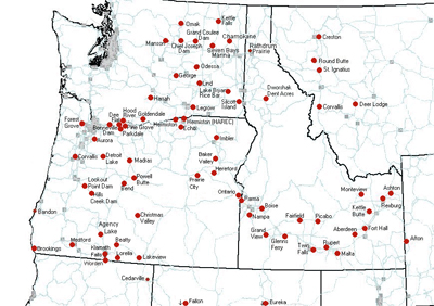
Competition for limited water resources in the western United States is increasing, as are the costs for moving irrigation water. In most western states, irrigated agriculture is the largest single consumer of water. To help improve irrigation efficiency, the Bureau of Reclamation and Bonneville Power Administration partnered to create a network of automated agricultural weather stations in the Pacific Northwest known as AgriMet (Agricultural Meteorology). Having begun with an initial installation of three stations in 1983, AgriMet now gathers meteorological data from 72 stations throughout Idaho, Montana, Oregon, and Washington, with additional stations located in northern California, western Wyoming, and Nevada.
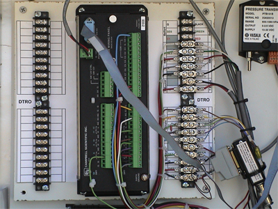
Each AgriMet station is solar powered, using a photovoltaic panel to recharge a lead-acid battery. The stations collect data required for modeling evapotranspiration (ET). Measured parameters include air temperature, precipitation, solar radiation, wind speed and direction, and relative humidity. Some sites have special sensors to measure soil temperature and moisture, crop canopy temperature and humidity, diffuse solar radiation, pan evaporation, and leaf wetness. Each AgriMet station is configured with sensors, a Campbell Scientific CR10X datalogger for data collection and processing, and a TX312 HDR GOES for data transmission.
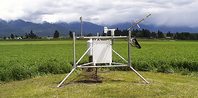
The CR10X measures each of the sensors once every second. The data is transmitted from the station via the Geostationary Operational Environmental Satellite (GOES) to the receiver site at the regional office in Boise, ID.
等信息用于生成各种各样的products and services to assist irrigators and water managers in efficient irrigation water management. There are four major products provided by the AgriMet program:
- A table of daily ET values for the last five days for a reference crop (alfalfa) and specific crops grown in the area
- 每个站的最后5天或10天的摘要天气参数表
- A summary of ET for each day of the growing season for each crop grown in the vicinity of each station
- Historical weather and crop water-use data for all stations for the entire period of record
All of this information is available on the Internet and is integrated into various on-farm technical assistance programs by local agricultural consultants, the Cooperative Extension Service, and the USDA Natural Resources Conservation Service. Use of AgriMet information in irrigation scheduling results in water and energy savings, reduced soil erosion, and protection of surface and ground water supplies. Various agricultural consultants have reported water and power savings ranging from 15 to 50 percent. Some irrigators have reported real savings of as much as $25 per acre in pumping costs after using AgriMet ET data to schedule their irrigations.
AgriMet not only provides information for irrigation water management, all of the current and historical weather information is available on the AgriMet website for a variety of user applications. Weather data is transmitted hourly from each station, and is almost immediately available on the website. This near-real-time availability of weather data from the AgriMet network finds many uses. The National Weather Service uses the hourly data for short term forecasting and forecast verification. Weather and ET data are used by state DEQs for investigating pesticide application and ground-water contamination issues. Electric utilities use the information to model heating, air-conditioning, and peaking-power requirements.
1990年代,太平洋西北地区西北部的成功扩大了大陆鸿沟。伟大的平原合作社农业天气网络在蒙大拿州中部维护和监控22家法师站。
更多信息可以在填写太平洋西北贸易局Agrimet网站上找到更多信息www.usbr.gov/pn/agrimetand for the Great Plains AgriMet program atwww.usbr.gov/gp/agrimet.